East Nusa Tenggara
East Nusa Tenggara Islands have been shaped by the power and force of an enormous chain of 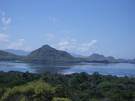 mountains and volcanoes, which begins from the North of Sumatra and stretches east across Java. The province consists of over 550 islands, but is dominated by the three main islands of Flores, Sumba, and Timor. Occupying a unique position at the junction ofAustralian and Asian submarine ridges marked by the Wallace Line, it is one the world's most dynamic and exotic marine environments with nearly every species of coral and tropical fish represented. The arid landscape of eastern and southeastern Nusa Tenggara is the result of hot, dry winds blasting in from the Australian continent. In fact, in many coastal areas not a drop of rain falls during most of the year. mountains and volcanoes, which begins from the North of Sumatra and stretches east across Java. The province consists of over 550 islands, but is dominated by the three main islands of Flores, Sumba, and Timor. Occupying a unique position at the junction ofAustralian and Asian submarine ridges marked by the Wallace Line, it is one the world's most dynamic and exotic marine environments with nearly every species of coral and tropical fish represented. The arid landscape of eastern and southeastern Nusa Tenggara is the result of hot, dry winds blasting in from the Australian continent. In fact, in many coastal areas not a drop of rain falls during most of the year. Flores is a Portuguese name, which means 'flower' and ideally describes the beauty to be found here. This long island between Sumbawa and Timor is crowded with volcanoes and mountains dividing it into several distinct regions with individual languages and traditions. Predominantly Catho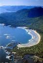 lic and heavily influenced by the Portuguese, there are many examples of a strong European cultural heritage like eastern procession held in Larantuka, and the royal regalia of the former king in Maumere. lic and heavily influenced by the Portuguese, there are many examples of a strong European cultural heritage like eastern procession held in Larantuka, and the royal regalia of the former king in Maumere. Formerly known as the Sandalwood Island, Sumba is now famous for its horses and an excellent style of ikat cloth. Spirits, both ancestral and natural are worshipped. Although some exist in East Sumba, it is in West Sumba that there are a number of enormous megalithic tombs and traditional thatched and peaked huts raised on stilts. It is here where incredible rituals take place, such as 'Pasola' where hundreds of horsemen fling spreads at each other in an annual ritual. Many traditional ceremonies, all with a component paying homage to the spirits, take place from July to October including the traditional houses and burials when sometimes hundreds of pigs, water buffaloes, horses, and dogs are scarified. Other ceremonies include 'Pajura' or traditional boxing, festivals for the Lunar New Year in October and November, horse races and ritual dances. GEOGRAPHICALLY
East Nusa Tenggara is one of the four provinces in the Nusa Tenggara (Southeast Islands). Starting from Bali, West Nusa Tenggara, East Nusa Tenggara, and east Timor. It stretch is between 118° and 125° east longitude, and between 1 18° and 125°southern latitude lines, and between 8° and 12 ° southern latitude li nes. The territory of East Nusa Tenggara Province comprises 566 islands. The three main islands are Flores, Sumba, and Timor from which come the term FLOBAMOR, which has been familiar as one of the names of East Nusa Tenggara. nes. The territory of East Nusa Tenggara Province comprises 566 islands. The three main islands are Flores, Sumba, and Timor from which come the term FLOBAMOR, which has been familiar as one of the names of East Nusa Tenggara.
Flores is the main volcanic island and has many unique and spectacular attractions, one of these is Mount Kelimutu with its lakes of distinct color variation, has become one of the fabled destinations travelers.
Sumba is the island famous for its arts, handicrafts, particularly the textile weaving, and cultural assets. The other name given to East Nusa Tenggara is "Nusa Cendana" the Sandalwood Island. GEOLOGICALLY
Geologically, East Nusa Tenggara can be regarded as being divided into two zones: first, the volcanic inner curve formed by the islands Rinca, Komodo, Flores, Alor, Pantar, Adonara, Lembata and Solor, which have fertile soils and second, the out curve with limestone and rock formation, made up of the island Sumba, Sabu, Rote, Semau, and Timor. DEMOGRAPHY
The total number of NTT inhabitants in 2001 was 3,888.735 - 1,919.644 (49.36%) men and 1,969.091 (50.64%) women. The most populated is Manggarai regency (621,989 people) and Kupang city is the most densely populated (1,517.30 people per square kilometer). CLIMATE
Due to central highlands and their closeness to Australia, the seasons are irregular. Generally the islands are semi-arid, with a longer dry season lasting from March to November. The wet season lasts from December to March, but can be considerably shorter and small island of Savu. The average rainfall of this region is between 36 - 4,127 mm/year. The temperature is range from 20.3 C to 31.7 C. TOPOGRAPHY
East Nusa Tenggara is mountainous, and very steep slopes are everywhere besides some not too wide plateaus or uplands. The lowlands are a long the coastal areas only. Despite of the situation, most part of this region is not fertile, since the rainfall varies between 500 mm and 2000 mm a year.
East Nusa Tenggara (NTT) is includes 566 islands. In addition, there are 524 uninhabited islands. It covers an area of about 47,349.9 square kilometers, including 200,000 square kilometers of maritime territory. Roughly 57 percent of the territory is hilly, with cliffs. The lowlands lay generally around the beaches and river mouths. WIDE AREA
The area of East Nusa Tenggara occupies an area of 49,879.98 square kilometers, and has a population of more than 3,500.000. It is divided into 12 regencies and one municipality. Kupang regency is the largest region (7,178.26 square kilometers) and the smallest region is Kupang city (160.34 km2). LANGUAGES
There are a lot of languages spoken in East Nusa Tenggara coming from as many different which groups of the population. Bahasa Indonesia is the national language in Malay, written in Roman script and based in European orthography. In all tourist destination areas English is the number one foreign language fairly spoken and written.
|
|
Information and pictures courtesy of Indonesia Tourism. |
|